Thursday, November 2, 2017

Chaulher-Dundha-Pimpla(Kandala) - Unexplored Baglan Forts

Until a week ago before actually going to these three forts, we were debating on options for our Trek plan on 28-29 Oct 2017. Options were Mangi-Tungi, Nhavigad, Chaulher, Pimpla, Bhilai, Premgiri, Rajdher, Indrai. After the required discussion, ifs and buts, we decided going to Chaulher, Pimpla, Bhilai, Premgiri. But two of our trekking friends Praveen Potdar and Sarvesh Tawade, who had earlier visited these forts, suggested that Bhilai fort is just a mountain and not much to see on the top after two hours of exhausting hike. We decided to cut Bhilai from our plan. For getting details on the route, I called Onkar Oak, who is an avid trekker and regularly writes travelogue in newspaper. Onkar said if you are leaving Bhilai, just because there is nothing to see on top, then Premgiri is also of same category. So, as per his suggestion, we decided to explore Dundha Fort and Mahadev Shilp Mandir in Deolane. The strange thing about going to trek is you plan too much and when you are actually on trek, all plans go for a toss. This is how our itinerary looked like on Friday 27th Oct 2017:-


Instead of leaving at 4 AM on 28th Nov, we left Thane at 5 AM (kyunki India mein koi time pe nahi nikalta). With my experience of our group and timing adjustments, I had already considered buffers in the departure and arrival timings. In the dark of morning, we 7 trekkers (4 guys and 3 girls) started our journey to Baglan region in Nashik by Maruti Ertiga. As we were reaching near Kasara Ghat, Sun god threw bright rays to paint the sky golden. We could feel the cold air and lukewarm sunrays hitting us at same time, to give a soothing effect. Before hitting Kasara Ghat, we had a Pee cum Potty cum Breakfast stop at Baba Da Dhaba. This Dhaba serves Hot Idlis, Medu Wada and Misal Pav from early morning. The best thing I like about this Dhaba is the way they serve Tea in glass cups,very rare we find in restaurants in Mumbai. Baba Da Dhaba location coordinates 19.6746402,73.4991751

By doing output and input exercise at Dhaba, we were back on Nashik Highway cruising at decent speed. As soon as you reach near Igatpuri, a group of forts welcome you on right side, Alang-Madan-Kulang-Kalsubai-Mordhan, standing high and handsome. On left Kavnai fort doesn't leave your sight till you pass Ghoti junction. Further Dangya Pinnacle pops up like an inverted nail.  It feels as if you have entered into an empire of forts and pinnacles. Group was as usual chirpy throughout the journey, pulling each other leg and bursting very very bad PJs.

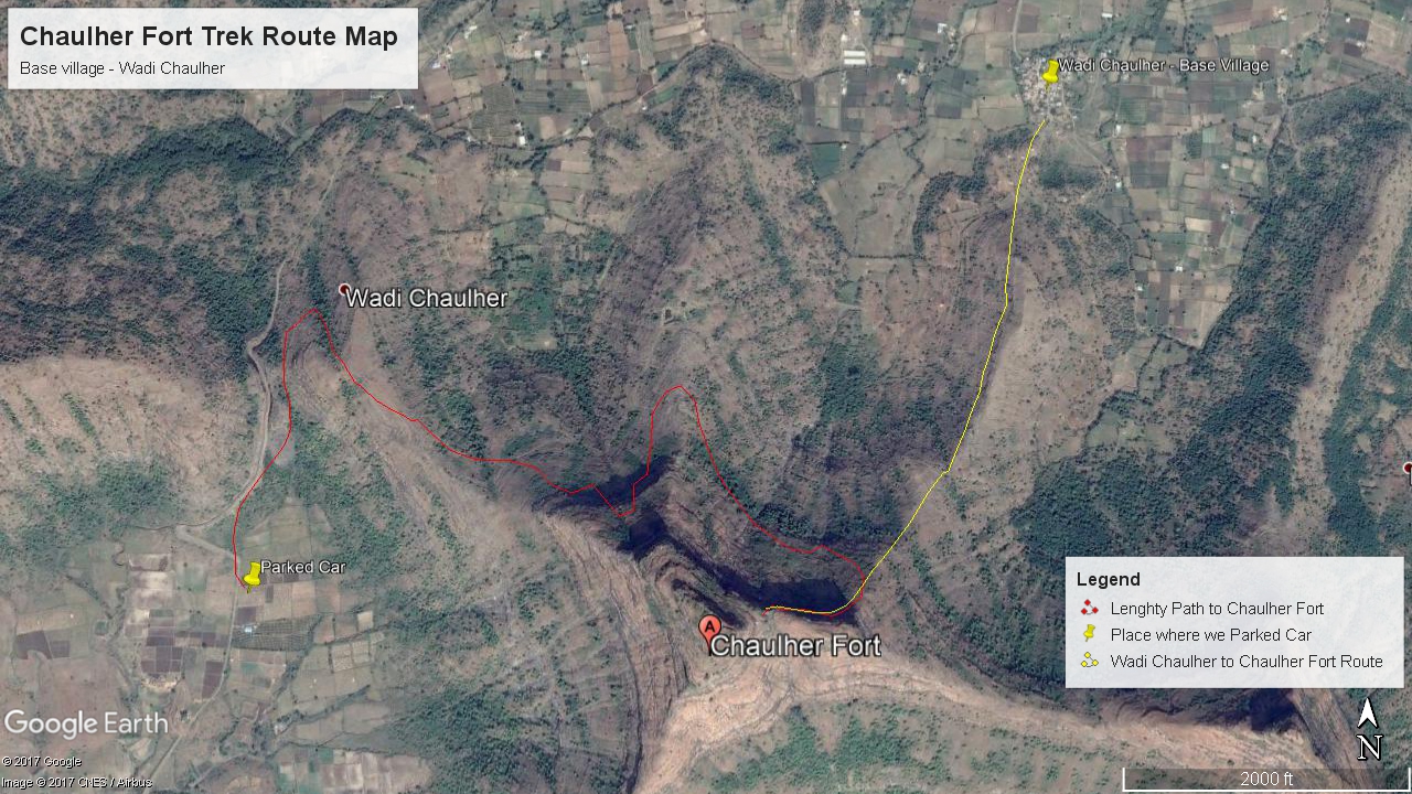
Moving on same highway you cross Nashik - Ozhar, again you see range of forts standing on left side, Saptashrungi, Rawlya, Jawlya, Markandeya, Dhodap, Kanchan Manchan, Koldher-Rajdher-Indrai and on the far north you can see Chandwad Fort. Just before Chandwad, you take a left towards Deola and your vehicle goes between Koldher and Kanchan-Manchan Forts. The whole ghat road is very picturesque, making you feel small in front of giant mountains. After reaching Deola, we made our first mistake of entirely relying on google maps to reach Wadi Chaulher. For reaching Chaulher Fort base village, Wadi Chaulher, you need to take route of Deola-Satana-Tilwan-Wadi Chaulher. Instead we took, Deola-Kalwan-Bhadwan-Visapur, as a consequence we reached a kuccha road on south side of Wadi Chaulher and in between stood mighty Chaulher fort mountain. Enroute, we asked villagers in Bhadwan about the route to Wadi - Chaulher. First of all, they were entirely clueless about existence of a village like Wadi Chaulher. Then they started to ask from where we are and if ladies are there in your group, then you shall not go in that region, as there are adivasi villages in the area. In two mins, the crowd grew from 2 to 15 people, they suggested to go from Chacher village, which we have never heard from the blogs and experiences of trekkers. I asked Avinash to press the pedal and take the vehicle as per google maps suggested. Further at Visapur also same response from the villagers, even though wadi chaulher was showing only 2 kms on GMaps. We continued on Gmaps route and reach kutcha road. Don't know when Google maps will become intelligent enough to show bad road and good road conditions in remote places. Below is the image of the route we took vs the route we shall have taken:-


We parked our vehicle at an unknown location and decided to directly get to the longer arm of the mountain on northwest side. We were pretty sure that the arm will take us to the door of the fort, but we were wrong again. We hiked the first ascend, which was full of scree, after reaching the plateau, we realised that there was big rock wall standing on the top of the arm, which was difficult to climb. Chaulher was laughing at us sitting on top, it started testing our endurance. Further on north side, we could see a ancient structure and a small water tank besides it. From that structure the northern arm of Chaulher fort started. We decided to traverse the mountain to reach there, it was a long walk but the constant breeze in the air helped to keep our bodies cool. As we reached the structure, we found a well trodden path making a traverse again and reaching to the center of the fort wall, where we could see the fort doors. This route was whole of thorns, bushes and all types of insects. Now we could see a clear and well trodden path coming from a village underneath the mountain, which was coming on the north eastern arm of the mountain with proper railings right to the top. Still we were not able to identify the Wadi Chaulher village. Let it be, we decided to move in the directions of fort door. It took us close to 2 hours to reach the fort door, by the route we took. Please find the google earth image below:-


Door has 3 forts for entry, excellent military strategy in case of attack on the fort. These doors are living example of brilliant architects who use to design impregnable forts. After going through the last door, you move up from the right side to the top of last door. From top, as you see down in the valley to the left of first door, you can find a beautiful hidden water tank with pure water. But the approach to that water tank we couldn't find, or one would need a rope to reach there from the first door. Further we moved towards left of the Citadel or BalleKilla, there is Hanuman idol and Chauranginath temple. Moving ahead to the temple, you can find water tanks on left Machi of the fort, water tanks are full of green moss. We came back to the last door and decided to explore the right side of citadel, as we couldn't find a way to the top from left side. There are three big tanks on the route, we tried to drink water from the first tank but it didn't taste good, water in rest two tanks was deep inside and no approach to go down. After you move ahead 30-40 steps from the last tank, you find steps cut in rock approaching towards the top of the fort. You will find a main door to the citadel and then two doors to the main structure on the citadel. As it was post monsoon season, grass was tall and thick, chaulher fort top was full of tall grass and thick bushes. Just 20 ft ahead, I saw a thin and long snake crawl into the bushes. Therefore, without wasting time we got down from the main citadel and made our way back through the 3 doors. Our descend started the same route as we came, because there was no option but to go back towards our car.

View of Chaulher Fort from the place we parked our Car

Walking the Long Long Long Traverse
First Door of Chaulher Fort


Fort Doors of Chaulher


Beautiful water tank hidden just above the first door
Steps going to the citadel

Fort Door and Remants on the Citadel

Water Tank on the plateau below the fort mountain

Slowly and steadily we descended the fort. I had the pleasure of taking dip in the small water tank enroute where village young boys were enjoying. I asked them name of the village by showing direction, they said 'Wadi Chaulher'. Atlast our suspense of location of Wadi Chaulher was broken. At that moment I decided to write this blog and guide future trekkers to the right direction. Wadi Chaulher is the base village from which trek is easy, you need to reach Satana-Tilwan-Wadi Chaulher, don't wander off like us. Negotiating scree patches, we descended to our car, had lunch besides road under a tree. Our next destination was calling, Dundha fort. It was already 4 PM, we were well behind our schedule, you can see the itinerary on the top.

Moving our vehicle in twists and turns, ups and downs we crossed Satana. Internal roads in Nashik are considerably good, even though it was post monsoon season. We first decided to explore Mahadev Shilp Mandir as our plan was to stay at base of Dundha fort, so even though we were late to reach base, we could explore the fort in morning. But the further story is very interesting. After Satana, taking help of GMaps, we reached Deolane around 4.45 PM and asked two bike-borne guys directions to Mahadev Shilp Mandir. They asked us to follow and in 5 mins through small but lively Deolane village, we reached Mahadev Shilp Temple (20.632571, 74.306736). The first view of Temple was amazing, though small, it resembled Mahadev Temple in Ambernath and Sinnar. Lot of fine carvings on the stone temple, seems to be made from a single rock. Some of the carvings resembled to carvings at Khajuraho, giving proof that India taught the world ways to make love. Inside the main foyer of the temple, Shiv Ling was residing silently. Beside the door of the foyer, there are idols of goddess carved in stone on both sides. People of Deolane have given paint to the top conical structures of the temple, due to which the temple has lost its natural touch, but appreciate their efforts to keep the temple standing and surroundings clean.

Mahadev Shilp Mandir, Deolane

Mahadev Shilp Mandir, Deolane

Mahadev Shilp Mandir, Deolane


Left Deolane around 5.15 PM, Sun god was feeling sleepy and going down at faster rate. We had to rush, but finding Dundha fort was a big challenge. We continued according to GMaps and again found ourselves on kutcha road. Again the same response by villagers, they didn't knew about a fort called Dundha but only new about village called Dundhe. We came back on the main road and reached Dundhe village(20.641090, 74.348816). Two people got down from the car, Prashant and Smita, to ask for directions to Dundha fort. Smita came with the right information but Prashant came with a strange one. The shopkeeper in Dundhe village told him that there are 4 tigers on the Dundha fort mountain and you shall avoid going there. Those tigers sometime come down to the base, sometime they are sitting in the temple and adjacent rooms. We were looking at each other face, the shopkeeper told us to take permission of the Baba taking care of the Dundheshwar Maharaj Mandir and then only hike the mountain as it is very dangerous. When we reach Dundheshwar Maharaj Mandir (20.619532, 74.344728) around 5.45 PM, Baba told us that they are not tigers but 4 leopard cubs (Biblyaa) on the mountain who are hardly One year old. And they don't disturb or attack anyone. Baba told us that without any fear you can go uphill, explore the fort and return as per your wish, there is no danger on the fort. Villagers are purposefully spreading such rumours. Meanwhile, we also asked Baba if we can stay in the temple premises for night. To which he said, you are most welcome, also you can cook food in my kitchen for the night. We started to climb the mountain, as it was getting dark, we took torches. Approach starts just behind the temple and in 15-20 mins, we were on the top of fort. Dundha fort mountain is full of heavy greenery and all types of huge trees, unlike other forts in Nashik, where you seldom find any big tree. We explored the Mahadev Mandir and potable water tanks besides them. Some miscreants had thrown plastic bags in the water tank. Dev Taaka, Bhim Taaka are name of the water tanks on the fort top built in rock. As we walked towards right side of the Mahadev temple, in 300 mtrs we come across a huge rock, from their the view of the surroundings was amazing. Our group spent around 30 mins sitting on the rock and enjoying the view as sun god went down to sleep completely. In dark, we made our way through bushes to the Mahadev Temple. Enroute we made jokes about what we will do if Leopard comes in our way. But, there was no sighting of leopard till we got down to the Dundeshwar Maharaj Mandir.

Left is the Dundha Fort Mountain

Dundheshwar Maharaj Mandir

Info on the fort at Base of Dundha Fort

Shiv Temple on Top of Dundha fort

Beautiful Shivling inside the Temple on Dundha Fort 


Baba in the mandir was kind enough to not only share his kitchen but also provide ingredients to make rice and tur dal aamti. Baba's house was just besides the mandir, but it was not like any ashram made of leaves or sticks, it was a proper RCC bungalow (G+1) with Dish TV. After Dinner, we said goodbye to the day in a big hall newly constructed in front of the temple.

Sunday morning was pleasant and the surroundings of Dundeshwar Mandir were looking beautiful in daylight. By 8 PM we completed our output exercise and rushed to Satana for input exercise. Satana was just waking up when we reached there at 8.30 PM. Pimpla fort was a good 40 kms from Satana, so we decided to have breakfast to our heart's content. Near to Satana ST stand there are multiple hotels were you can have a good breakfast in affordable prices. Our next destination was Malgaon, which is one of the three base villages of Pimpla Fort. We decided to reach 'Dangsaundane' and ask exact directions to Malgaon, as we had wandered off due to excess usage of GMaps the previous day. In rural areas, there is difference between how you read a place name and how it is pronounced locally. When we reach Dangsaundane, we were asking 'मळगांव', but there were empty expressions on the face of villagers, as if we asked about 'California'. By showing them google maps and the direction we intend to go, they finally said you are suppose to go to 'मळगा'. So, this is how they pronounced Malgaon. And ofcourse they didn't knew about Pimpla fort, no need to explain why.

So, there are three approach to Pimpla Fort, One from Sawarpada, second from Vathode and Third from Malgaon. First of all you shall know that local people call the fort mountain as 'Kandala' or 'कंडाला' . The approach from Sawarpada is regularly used by trekkers, but it is lengthy and to come to the base of the mountain, it takes 2 hours and further 1 hour. Almost same thing from Vathode village. Best is you start from Malgaon village, which is situated just under the eastern arm of the fort. We reached Malgaon around 10.30 PM. Malgaon village is not less than the picturesque villages you see in bollywood films. With mountains surroundings from all sides except from the east, the village is gorgeous with agriculture booming in the valley. Villagers were busy with harvesting season and didn't have much time to see who have arrived in the village. We asked for a guide, who could take us to the mountain top, so we could avoid wasting time. But everyone was busy and reluctant at same time.Even though Pimpla fort peak was visible from the village, we were not sure if we would find the right route. A farmer with his two bullocks was kind enough to guide us to the start of the trail, also showed us the direction we shall follow on the mountain to reach Kandala fort. We parked our car near a villager's house. Moving through fields of Bajri, Corn, Rice, Nagli, we reached a trail going upwards in the direction of fort.  A prominent trail starts from the road opposite to the earthern dam of Malgaon village. Google coordinates of starting point are 20.634878, 73.934737. 


You don't leave the well trodden trail till you reach the second plateau, in between you go through Nachni (Ragi/Nagli) fields. Further the trail was lost in tall and thick grass, we were on our own again. But as we had proper sense of direction, thanks to the farmer, we continued on the path entirely covered by grass. In approx 1 hr 15 mins, we were near the northern face of the Kandala fort. We could see the big cave, but the cynosure of Kandala fort is Nedha (hole in the fort wall), we were not able to locate yet. We hiked upto the three water tanks which were on left side of the cave, again the water didn't seem to be potable. Cave on the fort was also Nedha initially, but was closed on one side due to fallen rocks. Cave is big enough to accommodate 20 people, but the head space is very less, if somebody doesn't take care, he/she is ought to get injured. We had a good photography session in the cave. To locate Nedha, we opened information of the fort saved in our phone. We came to know that Nedha is just 30-40 steps ahead of cave in eastern direction. We rush to the spot and were awed by the natural wonder. It was a good 70-80 feet wide, 10-15 feet height hole in the mountain of Kandala fort. On the other side, it seemed like entry window to the planet earth. Again click click click, our photos and poses were not stopping. Just besides the Nedha, the mountain is divided into two parts, from there by easy rock climbing you can reach the left top, which has water tanks and amazing view of the surroundings. On the right top, there is not much to see, you can just go to the end and come back. Panaromic view of Baglan and rural Nashik is amazing from the fort. On northern side, towards Mah-Guj border, you can see the whole range of Salher-Salota-Mulher-Mora-Hargad. Just left to the Salher fort, there is Takara pinnacle looking dangerous but determined. On Southern side, you can see Dhodap and nearby forts. It was a clear day, we could see clearly till 70-80 kms in all directions.


Pimpla (Kandala) Fort from base village Malgaon

Path Lost in Grass

Entry to Planet Earth

Nedha on the fort

Pimpla/Kandala Fort

Malgaon earthern dam

Panorama view from Pimpla fort top


Spending a good one hour on the fort, we started to descend from the same path. We lost the way one time, but were on the right trail in few minutes. View of Malgaon earthern dam was amazing, it was inviting us to take a dip and then continue journey back to Mumbai. But we were running out of time, as there was around 6 hours of journey back home. We returned near our Car around 2 PM, ate all the fruits we had and via Kalwan-Deola-Chandwad, we reached Mumbai highway. We would have avoided 20 kms if we went via Vani, but as Avinash said the road condition is bad, we decided to move via Deola. By taking two small breaks, we reached Thane around 8.30 PM and there were goodbyes and promises to meet again. We were half n hour early than what I planned in the itinerary, Bravo, Kudos !! Lot of thanks to our group Mahesh Gavasane, Smita Gavasane, Avinash Jadhav, Samidha Jadhav, Prashant Salunke, Arpita Gavankar & Anurag Chivilkar.


Gadhegals and Veerghals Enroute during Trek


Friday, January 29, 2016

Mahipat-Sumar-Rasal Forts - Adventurous Trio

After exploring sea forts in last two tours it was time to explore hill forts in Konkan. Some of the members in our group, were talking about this trek since last two years but we were not getting any opportunity to execute it. As this range requires a good three days to explore, we weren't able to find convenient three dates back to back as most of our group members work with reputed companies and getting holiday is a task. Finally, we zeroed down on dates of 23-24-25 Jan 2016, as 23-24 Jan were Saturday and Sunday, 26th Jan is a public holiday, everybody decided to take a casual leave on Monday 25th Jan, so they can rest the next day after trek and resume office from 27th Jan. After some friction in the number of members joining this trek, 8 people were finalised and for travel purpose Two Wagon R's were finalised. We collected some primary information from the blogs written by trekkers who had previously visited this trio, spoke to them on phone, gathered all details from books like "Sangati Sahyadri" and Gazeteer website. We came to know that Sumargad has a 50 feet rock patch, which is a bit tricky at certain stages and there is a need of safety rope for same, although villagers have fixed a wire on the patch. Just not to take any chances, we arranged a rope from one of our member's friend. Finally the plan was ready and all were eager to execute it.

Some of the group members had questions about doing this trek by vehicle, as lot of trekkers do this exhausting trek by walking around 30-35 kms. The original route for trekkers start from Dahivali, this village is parallel to Kashedi Ghat towards Mahabaleshwar, it can be reached from Khed by ST or by hiring private vehicle. Then the route goes from Dahivali - WadiBeldar(3 hours) - Mahipatgad(1 and 1/2 hour) - Sumargad (1 and half hour) - Rasalgad (6 hours), all this route by walking. The whole route tests the stamina and willpower of trekker. But as we studied and gathered details, we came to know that State Tourism dept has been working hard to convert these forts into famous tourist spots like Raigad and Pratapgad. A road till Rasalgad base has been completed and your vehicle can reach the base, from where it is only 30 mins climb to top. Likewise, road is being constructed till Wadi-Jaitpur, from which you can reach Wadi Beldar 3 hours by walking, which is base village for both Mahipatgad and Sumargad. Hoping for the best we started from Panvel on Saturday 23rd Jan morning and reached Khed around 3 PM. Just before you reach Bharana Naka, Khed on Mum-Goa Highway, you can see sign boards indicating Left Arrow to Mahipatgad and Rasalgad. Taking left from Bharana Naka, in just 17 kms you reach base of Rasalgad. The final 2-3 kms of the route is still being constructed and passes through a long traverse, left hand side of which is a deep valley, please beware while driving. We reached Rasalgad as sun was going down. It was being said by previous visitors that sunset at Rasalgad is one of the best you will be seeing in your life. Rasalgad gives an awesome 360 degree view of ranges in Konkan and Mahabaleshwar.

Rasalgad, from the place where we parked our vehicles

First door of Rasalgad

Hurriedly we gathered our bags, left vehicles at the base and reached top in 30 mins, to see the sunset and click pictures. Enroute we came to know from a villager that there was a function at the Zolai Devi Mandir on the fort, called 'Gondhal'. All of the group members were happy that they will be getting a good hearty meal without paying anything because of function in the temple. There are two most prime qualities of trekkers, first they are no.1 bhukkads and second they are no. 1 jugaadus. After reaching top, we left our bags in the temple which was our abode for first night, temple is spacious and 20-25 people can easily accomodate inside it. We decided to explore the whole fort in morning and without wasting time we reached the western point of the fort from which the sunset was looking beautiful. For around half hour camera clicks were not stopping and we did lot of photography before sun finally went down.
 

Zolai Devi Mandir on Rasalgad

Deepmal in front of the Zolai Devi Temple


One of the best moments of this trek

At night, we participated in the function and ofcourse had a good lunch after that. One more group of middle aged men were partying in the same premises, they shared a local cuisine called 'Popti' with us, which is cooked in a pot having layers of chicken, eggs, beans and locally available leaves called 'bhamburda'. Before going to sleep, we went for a walk on fort, as it was a day next to Pournima, whole sky was glittering due to moonlight. Back to the temple, we had a chat with villager and gathered details about the further journey.


Gondhal Function at Zolai Devi Temple


 Zolai Devi Idol

 
 Feasting on Popti


Moon was its best, emitting lovely light
We woke up at 6:30 AM, completed morning chores and we started to explore the fort as sun was coming up. You can find two water tank just near Zolai Devi Temple, one of them is potable and there is a beautiful deepmaal in front of the temple. Just near the temple there is Balekilla, which has lot of remnants, well maintained by the villagers with help of local politicians. There are lot of canons on the fort, in the gazetteer it is said that fort has total 23 canons at different spots. Other than this there is a grain storage, lots of water tanks and idols of various dieties. But the cynosure of all is 'Khamb Taaka' which means pillared water tank, to reach it you shall walk straight from door of the temple in east direction and come to a narrow end where you will find a Stone wall of about 5 feet, just on right side of the wall there is a steep path going down. Take care while going down as the path is full of loose soil and slippery grass, villagers advised us not to go that side but we wanted to anyhow see that water tank. At the end we found that if we descend with care, that patch is not much difficult, but still one needs to get down with care. Atlast, our effort was fruitful as we discovered 'Khamb Taaka', pillars of which had beautiful carvings. Happy with our exploration, we came back to temple, collected our bags and got down the fort.

 
Lots of Canons on Rasalgad, Booommm !!!


 Storage Structure on Rasalgad

 
Small Devasthan at Rasalgad

 
Khaamb Taaka (Pillared Water Tank)


 Zolai Devi Mandir, Rasalgad

Back in our vehicles, our next target were the mighty Mahipat and Sumar Gad. As per our plan, we had to reach Wadi Jaitapur and then walk towards Wadi Beldar. From Rasalwadi, you need to come back to Rasalphata, turn right and after almost 7-8 kms you need to take right again, on every turns there are proper sign boards erected by Tourism board. As per the villager whom we met on Rasalgad, there is a construction of road going on till mahipatgad, only 2 KM is remaining, but the road after Wadi Jaitapur is 'kuccha'. He advised us to proceed ahead of Wadi Jaitapur, till you find road not suitable to go ahead. A kilometre ahead of Wadi Jaitapur we came across an Engineer who was on bike and was working on the road going upto Mahipatgad. He told us that you can go 2 more kms ahead, keep the cars and then proceed to Wadi Beldar by walking. As per his instructions, negotiating steep and not so good road we reached a cliff where road was turning U and ahead of that construction was going on. We parked our vehicles on the cliff, packed our bag and got ready for the climb ahead to Wadi Beldar. We were fortunate enough, as our climb was reduced by almost 1 hour due to the newly constructed road. There are electric poles going from wadi jaitpur to wadi beldar, you have to follow those poles throughout the route.
 
Place where we parked our vehicles, Far ahead in centre you can see Sumargad


Steep kuccha road through which we came up from Wadi Jaitapur


After almost 1 and half hour walk under hot sun, we reached Wadi Beldar at Mr. Sitaram Jadhav's(+91 7038923580) house around 12:00 PM, who was going to be our host and guide for next one and half day. We had our lunch at a house nearby made by a nice and warm lady Jijabai, food was awesome and had a motherly touch.
Tummies filled with homemade food, we decided to execute our further plan with a small change. Our original plan was to go to Mahipatgad and stay there for night, but as we had reached Wadi Beldar before expected time, we decided to do the thrilling Sumargad first. At 1:30 PM, leaving our bags behind, we started moving towards Sumargad behind our guide Sitaram Jadhav. If we keep our back towards Wadi Beldar, you need to move left towards south. First 15 mins of the walk towards Sumargad is steep, rest of the 45 mins walk is on ridge and most of the times straight walk. In 15-20 mins, you reach a small house called "Raya Dhangarachi Zhaap", which is small hut of a shepherd called Raya, who has all detailed information about the surrounding areas. We were fortunate to meet Raya and told him that we had read about him in all books and articles, which has mention about these trio forts. You have to walk around 3 hills to get a clear view of Sumargad, enroute we could see our car far away parked on the cliff. By continuously walking, without taking any break you reach 'Gur Khind', from where straight path goes to Rasalgad and left goes to Sumargad. Here you need to take care that, don't take any heavy baggage on sumargad, as the path is very tricky, just take a small bag with you having water, that too we left on a tree near 'Gur Khind'.

 
Raya Dhangarachi Zhap (Shepherd's Hut)

Raya Dhangar with Energy Drink, Sitaram Jadhav with Sickle

 
View of Sumargad after coming up from Gur Khind


Way to Sumargad after coming up from Gur Khind


Sumargad

 
Really Unbelievable !!! View from Sumargad


Need to pass those three hills to come towards Sumargad, far ahead right hand side you can see Mahipatgad

We started ascending the steep path going towards left with all the loose soil you can imagine, while going up we were wondering how we will come down from here while returning. After initial 10 mins climb, you come on the long arm of sumargad and then traverse from the left hand side of Sumargad base takes you to the famous 50 feet rock patch of Sumargad. Just before the rock patch, there is a very tricky traverse which you need to negotiate patiently while keeping utmost balance. While doing this traverse, you need to touch your back completely on the rock and moving inch by inch sideways, maintaining balance you can complete this small but tricky patch.

  
It was that moment when you start to think, better if you had spent weekend sleeping at home
Further you come across the 50 feet rock patch, which is standing almost 90 degree, but there are proper holds at all places. There are two iron ladder (4-5 feet) placed by villagers at 1st and 3rd stage of the patch, also a thick wire runs along the length of patch which acts as a mental support in case you lose balance. If you are new to sahyadris, this patch can be very scary but if you been well acquainted with challenges of sahyadris then this patch is not much to worry about. Our guide Sitaram Jadhav told us to climb the patch without footwear, which will give good grip on flat patches. 1st and 3rd stage of the climb are not much to worry about, but the 2nd stage has some loose rocks, it's better to find a reliable rock to push yourself up or use the wire for support. Ladders placed by villagers are not anchored to the rocks, so everytime someone is climbing on it, other person has to hold it so there is no chance of slipping. Finally at 3 PM we were on the top of fort. There are three huge water tanks in front of the cave which houses a Shiv Temple. Just above the big water tanks there is a small potable water tank, from which you can drink water till heart content, guess it remains throughout the summer season. Top of the fort is a small area, on the southern end you can find a 'Khamb Taaka' (pillared water tank), which is same as Rasalgad but without carvings. Other than this there are few remnants which resemble a storage structure. After half n hour we decided to descend the rock patch, and this time it was more scary than going up as we can see the whole valley just below our feet. By keeping patience and maintaining balance with the help of wire, we successfully descended the rock patch and in 20 mins reached Gur Khind, where we collected our bag and water bottles.
  
Start of the rock patch at Sumargad, you can see a black wire hanging which is for support

Rock patch at Sumargad


Descending the Rock Patch at Sumargad


Water Tanks at Sumargad, one above these water tanks is potable 

 
Potable Water Tank at Sumargad

 
Idols on Sumargad

Khamb Taaka at Sumargad

Further we descended to a small water stream near Wadi Beldar, where we had a good bath and spent a great time. Some of our group members were murmuring that we can now leave for Mahipatgad, which is 1 hour from Wadi Beldar and stay there for night. But atlast we decided to stay in Wadi Beldar and explore Mahipat next morning. After having dinner at Jijabai's house, we retired for the day in Sitaram Jadhav's house. You can find mobile range in whole region of this trio forts, which is very surprising because it was a remote area and to just go for shopping you have to walk for 3 hours to Wadi Jaitpur. Well, I guess the region is only 20 kms radius of Khed, so there is no problem of mobile network.
On 25th Jan morning, we woke up late than planned as everybody was exhausted from previous day's hike. Nonethless, we started for Mahipatgad at 8:30 AM, our guide Sitaram Jadhav was suppose to take a different group to Sumar and Rasal, so he showed us the path and asked us to follow the electric poles right upto the Pareshwar Mandir, right in the centre of Mahipatgad. Mahipatgad is all covered with forest and villagers say that wild animals like Leopard, Wild cats, Wolves roam around the fort in broad daylight. Every year Mahipat gets a government grand of 5 lakh rupees, which is very less as compared to the rich heritage it carries which needs to be conserved. In one hour you can reach Pareshwar mandir from Wadi Beldar, enroute we came across a fort wall towards left, one stone dam after that and a big well on right side. Just before the stone dam, we met the Pujaari (priest) of Pareshwar Temple, he was hurriedly descending the fort as he wanted to leave for Mumbai. He gave us some information about the fort and what all you can find on it. Priest told us there are lot of things to see on the fort, there are 360 small temples and idols scattered all over the fort, also there are remnants and fortifications, but most of them are covered in dense forest and difficult to find. He also warned of us getting lost in the dense forest, as a suggestion he told that at every diversion you leave a mark as you go ahead, so it will help when you turn back.
 
 Stone Dam at entrance of Mahipatgad


The area around Pareshwar Mandir is one of the beautiful places I have seen. Just in front of the temple, there is a huge well, which has the most sweetest and coolest water you can ever imagine. There are lot of different butterflies and birds you can spot on the fort roaming freely in the wild. After seeing the temple, we wished we could have hiked the fort last evening and stayed in the temple. Temple is very spacious and accommodate around 30 people comfortably.

Pareshwar Temple, Mahipatgad
 

Mahipatgad


Mahipatgad
After few minutes, we decided to explore the fort on our own, but as Mahipatgad is spread over 120 acres that too in thick jungle, exploring the fort was a real challenge. Not to get lost in the forest, we decided to stick together and move in one direction, till we find a dead end or a valley or a fort wall. We decided to move in northern direction, enroute we saw some structures, idols and broken fort wall. After around 20 mins of walking and making marks on every diversion, we reached a cliff which was northernmost end of the fort. View from that place was mesmerizing and till today whenever I think of Mahipatgad, the view comes in front of my eyes. On the left hand side of the cliff, you can see two fort towers indicating the fort boundary. The fort is so huge that you cannot accommodate its expanse in just one view. On the cliff we had lot of photography. Far ahead on the right, we could see Mahabaleshwar table land and somewhere towards left of that you can see the entire range of Rajgad, Torana and Raigad. If we turn back, we can see Vasota fort, which is near Chiplun. You should be fortunate enough to get a clear sky like we had that day to spot all those forts from Mahipatgad. After spending half n hour on the cliff, we made our way back from the forest and came back to Pareshwar Mandir. Enroute we saw some excreta of Leopard and thus our return journey was far more quick.

 
Walking through dense jungle at Mahipatgad


And jungle opened up for a beautiful view at Mahipatgad


View from northern end of Mahipatgad


At left, you can see two fort towers from the northern tip of Mahipatgad

As you make way back to the stone dam, just after the temple there is a good path going towards right, some of our group members decided to give a try in pursuit of finding something new and some were skeptical because of getting lost in the jungle. Atlast, we went ahead on that path, which actually moves parallel to the normal path going towards the stone dam. After 5-10 mins, the path started descending and we met a villager who confirmed that same was going to Wadi Beldar but different than one we climbed up. This path led us to the fort tower which we could see on the left hand side while climbing up. Enroute we saw small idols and to our surprise canon balls were kept there, it was a pleasant discovery as it was not mentioned anywhere in the information we studied. After spending few minutes at tower, we started descending and further that path met the path by which we had climbed the fort just below the stone dam.

 
Canon Balls at Mahipatgad

In half n hour around 1 PM we were at Wadi Beldar, packed our bags and bid a good bye to Jijabai. Walking in hot conditions, we descended to the place where our vehicles were parked. Seeing back Sumargad was still watching us, asking to come back and take the challenge again. No wonder, this area will be commercialised after few days, due to efforts of state tourism board. Vehicles will start running, shops will come up, human movement will increase, heaps of garbage will fill the valley, all these things will ruin the beauty and serenity of this place. Hope the tourism board maintains certain amount of decorum while uplifting the area around Mahipat-Sumar-Rasal. We reached Mumbai around 9 PM and with happy memories of this adventurous trio. I would like to thank to my awesome group for this awesome trip, who are more than friends and have become one family now, Love you Guys !!


Our group - From Left to Right - Sarvesh Tawde, Nilesh Tawde, Praveen Potdar, Nilesh Nangre Avinash Jadhav, Mahesh Gavasane, Anurag Chivilkar (Myself), Darshana Bhosale Tawde